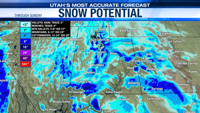
SALT LAKE CITY (ABC4) – Happy Sunday, Utah! Our next atmospheric river event is upon us, and heavy mountain snowfall will continue throughout much of the day today.
The valleys will continue to see rain and snow showers this morning with moisture clearing out this afternoon. The Winter Storm Warning for Utah’s mountain areas will expire over the southern mountains at 5 p.m. The northern and central mountains will remain under the warning criteria through 11 p.m. Snowfall totals are expected to range around 10-20″ for most of the mountain ranges with locally higher amounts possible in the Upper Cottonwoods and the Uintas. If temperatures turn cold enough for snow along the valleys this morning, a Trace to 3″ is expected for most areas. Winds will remain breezy today as the storm pushes further east. Highs will be near 40 degrees for the Wasatch Front, upper 40s for St. George.
As the storm clears out late Sunday, another area of low pressure will be right at its heels for early Monday in Southern Utah. The trough will likely dig a little further south than today’s storm and will primarily impact Central and Southern Utah. Limited moisture will move through portions of Northern Utah with the current forecast calling for some rain and snow showers as far north as Salt Lake County. Most of the heavy snow and rain will fall south of the Wasatch Front with healthy snowfall amounts expected for the Southern Mountains. Early forecasts call for another 8-16″ of snow for Brian Head through Tuesday afternoon. A few snow showers are possible for the southern Wasatch Front through Tuesday morning. As the storm rotates through Southern Utah into Tuesday, northerly flow will take hold up north and much colder temperatures are expected. Highs will be close to average through Tuesday and drop to near freezing for the latter half of the week.
We’ll see a break from storms on Wednesday with mostly cloudy skies expected. On Thursday, yet another storm will move through Northern Utah under northwest flow. As temperatures are colder, precipitation with Thursday’s event will be all snow down to the valley floor. We will likely see accumulations along the Wasatch Front and will keep you posted on snowfall estimates as the storm approaches. The storm will clear out late Thursday with quiet weather settling in for the first half of the weekend. Northwest flow will remain over the region into Saturday and temperatures will remain 5-10 degrees below normal during that time.
Bottom Line?! Active weather is sticking around through the long holiday weekend.
Always stay one step ahead of the weather with Utah’s Most Accurate forecast both on-air and online! We are Good4Utah!


