CNN —
As strong bouts of heavy mountain snow, widespread rain and gusty winds continue to sweep across the West and push into the Central US Thursday, more than 16 million people along the coast are under flood watches in anticipation of even more stormy weather to come.
Twelve states across the Western and Central US are under winter weather alerts as of early Thursday morning after a round of wet and wintry weather earlier this week flooded roads, blew hurricane-force winds and left thousands along the coast without power.
The dangerous conditions left five people dead in Oregon on Tuesday, including a 4-year-old girl, after severe weather caused trees to fall on passing vehicles, state police said. Wind gusts in the state on Tuesday exceeded 100 mph in some areas, according to the National Weather Service.
The forceful atmospheric river – a long, narrow region in the atmosphere that can carry moisture thousands of miles – is forecast to continue battering the Western and Central US after the initial round of moisture shifts eastward Thursday.
New rounds of rain and mountainous snow will inundate the coast into Friday before shifting to southern California and the Southwest through the weekend.
More coastal rain and mountain snow to come
As the initial wave of moisture hovered over Colorado overnight Wednesday, the Denver and Boulder areas saw as much as two inches of snow per hour.
More than 9 inches of snow had fallen over Boulder and more than 5 inches total were reported at the Denver International Airport early Thursday morning.
“Heavy snow will accumulate on tree branches and powerlines, possibly causing them to break and lead to power outages. Plan on slippery road conditions. The hazardous conditions could impact the Thursday morning commute.” warned the National Weather Service in Boulder.
The storm hovering over Colorado is expected to move out of the area Thursday morning and bring wet snow and isolated pockets of rain through Kansas, Nebraska and Iowa into Thursday evening. The storm will then move through Minneapolis, bringing a mix rain, snow and ice overnight.
Meantime, a new bout of moisture is expected to hit the West coast Thursday morning before a more forceful surge ushers in heavy rain in the evening. That storm system is forecast to remain focused on northern California, southern Oregon and northern Nevada from Thursday evening through Saturday morning before finally shifting to southern California and the Four Corners region through the rest of the weekend.
Snowfall across much of the West over the next five days is expected to be between 1 to 7 inches in lower elevation areas and 1 to 2 feet in higher elevation areas. Some isolated areas could see more than two feet.
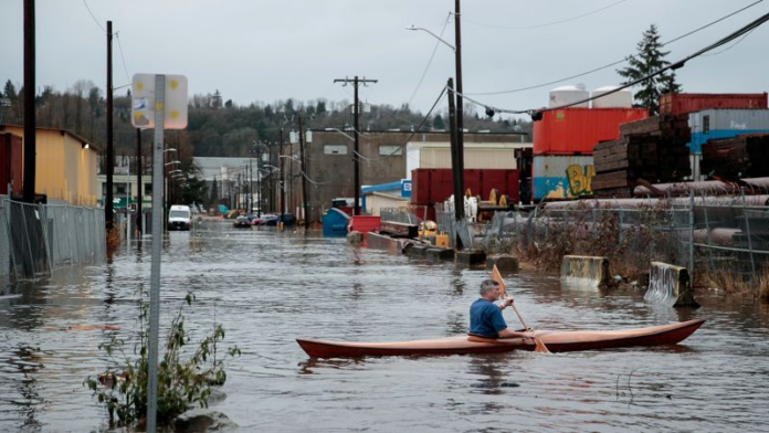
A person kayaks through Seattle’s South Park neighborhood on Tuesday, December 27, 2022. Erika Schultz/AP
The drought-stricken region is receiving a brief respite as much of central California and northeastern Nevada have already seen up to 2 inches of rain with some higher elevations seeing up to 4 inches. By Saturday, those areas could receive another 2 to 4 inches of rain or as many as 6 inches in higher elevation areas.
Over 16 million people in central California and northwest Nevada are under flood watches as of early Thursday, including those in San Francisco, Sacramento, Fresno, Oakland and Reno. The anticipated rainfall has prompted the National Weather Service to issue a multi-day slight risk of excessive rainfall for parts of northern California.


